bout de papier, Vol. 15, No. 4 (1998-1999) — Winter 1998/99 // Hiver 1998/99, pp. 28–31
Those who have had the pleasure to be posted to Ankara know very well the gem that Turkey is. From a professional point of view, the internal politics combined with the complex mixture of Turkey’s relations with the EU, Greece, Former Soviet Union and Middle East is enough to keep one very active and content. But besides that, there is the bonus of travelling in Turkey. Take your pick from any coast – Mediterranean, Aegean or Black Seas — not to mention Istanbul or the Anatolia plateau, and any history buff or beach bum could be kept busy for years.
A further bonus for some has been the opportunity to travel to areas not regularly visited, namely the south-east triangle between the borders with Iran, Iraq and Syria. Heaped with as much history as Istanbul, this former Silk Road intersection offers an incredible array of ancient civilizations and empires: Babylonian, Hurrite, Hittite, Hurrian, Uartian, Hamdanid, Buweyhid, Ayyubid, Assyrian, Cimmerian, Persian, Turkoman, Macedonian, Greek, Roman, Byzantine, Seljuk Turkish, Ottoman, Armenian, Kurdish
Ask most “Western” Turks in Ankara or Istanbul about travelling in south-eastern Turkey and your likely to get reactions ranging from blank stares to warnings of terrorist attacks. When you then tell them about enjoying night-time walks through the streets of Diyarbakir, they question your sanity.
In 1984, the Kurdistan Worker’s Party (PKK) began a campaign of terror in the south-east that has raged at times into all-out war. The government’s response – massive amounts of troops and martial law – has been questioned as to its effectiveness and its impact on civilians. For the people of the south-east the past 15 years has been one of attacks and counterattacks, village evacuations, migration and rampant poverty. It is estimated that nearly 30,000 terrorists, soldiers and civilians have been killed.
Although the region remains extremely tense and somewhat dangerous, the situation has begun to change slightly over the past three to four years. The military claim that they have won the war – although attacks by the PKK terrorists and large military operations continue. Only six provinces of the original ten remain under Emergency Rule and an economic turnaround, long predicted by the designers of the massive hydro electricity and irrigation Southeastern Anatolia Project (GAP), has begun to show hints of an impact. Most observers would say that a long-term solution to the “Kurdish question” depends on government recognition of the language and cultural identity of the mainly Kurdish inhabitants of the region. But nonetheless, the region is changing and visits to most areas are possible. Making my second trip in two years, in May 1998, I was excited to revisit Diyarbakir and see for the first time Van, Bitlis,
Şanliurfa and the famous Nemrut
Dağ (Mount Nemrut) with its incredible tumulus and statues. Part official visit and part exploring, I was looking forward to, on one hand discussing the effects of massive migration on ill-equipped cities, while rumbling through ruins and walking the streets that now cover the ancient paths of the Silk Road.
We began the journey in Turkey’s eastern most city, Van, 80 km from the Iranian border. Noted for the lake of the same name, Van was once the capital of the Urartian kingdom, at that time called Tushpa. After the fall of the Urartians, Van was occupied by Armenians, but they were never its master. Controlled by one dynasty after another, the Armenians of Van were passed from Romans to Arabs to Persians to Byzantines and finally to Turks. During WWI, the Armenians rose up against the Ottomans and fought alongside the Russians, who occupied Van for close to three years. When the war ended, so did the history of the Armenians in Van.
The City’s castle, or Rock of Van, sits in between the lake and the present day city. The unique, cuneiform writing on its walls was borrowed by the Urartians from the Assyrians, although they were bitter enemies at the time. Looking down from the castle, you see a maze of lumps in the fields that were the remnants of the Urartian city and until WWI, the homes of the Armenian community.
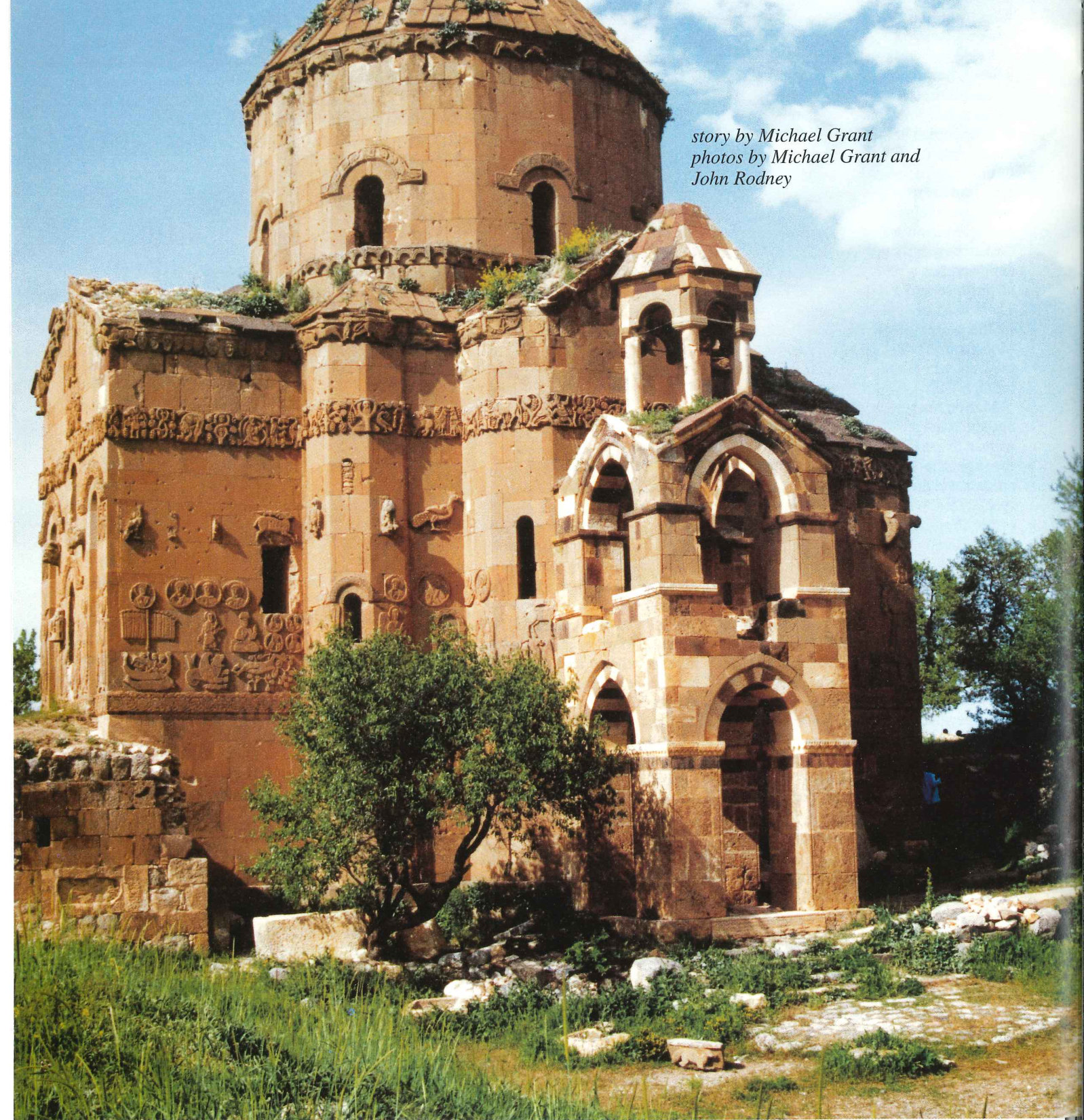
A short distance south of Van you come to the dock of the small ferry that takes you to Akdamar, an island a few km from shore on Lake Van. In 921, Gagik Vartzruni, King of Vaspakan, built a church and palace here. Today, nothing much is left of the palace, but the Armenian-style church is in terrific i condition. The view of the lake from the
– island is also spectacular. Besides the armoured personnel carrier escort, the trip from Van to Bitlis was a great drive through incredibly mountainous terrain. There were numerous checkpoints, but no problems were encountered. In Bitlis, the Deputy Mayor took me on a whirl wind tour of no less than five mosques all over 800 years old. The past significance of this small trading town was revealed when we then visited the ruins of two caravansaries, the ancient resting and meeting places of the Silk Road travellers. Near the end of the Ottoman empire, Bitlis was the capital of a semi-autonomous Kurdish region. During the fighting of recent times, Bitlis had its share of problems, but in 1997 it was removed from those provinces under Emergency Rule and, according to the Deputy Mayor, is now quite safe for residents and tourists alike. Modern day Diyarbakir is known mostly for being the centre of the Kurdish separatist activities. For most of the late eighties and early nineties its streets were not safe at night, having been essentially taken over by the PKK. While much safer today, the continuing security presence is one reminder of the fact that the 15-year struggle against terrorism is not over. The other reminder is the overflowing population caused by migration from evacuated villages and a birthrate of 3.5%. Diyarbakir has swollen to three times its size in 15 years, to more than I million, according to its mayor.
Even under its current strain, Diyarbakir offers some fantastic historical sites not least being the six kilometre walls that surround the city. Claimed to be the second longest outside of China, these black basalt walls offer fine views of the city and of the Tigris river.
Another favourite spot is the ancient caravansary, another stopping point on the Silk Road and now a functioning hotel. Its thick stone walls provide some comfort from the heat and the inner court yard is again a place for travellers to share stories of the east.
The most impressive mosque in Diyarbakir is the Ulu Cami, built in 1091 by Malih Şah, a Seljuk sultan. Clearly Arabic in style from its rectangular shape, Ulu Mosque looks across to yet another ancient caravansary which now houses shops offering quality carpets, kilims and bags from all over eastern Turkey, northern Iraq and Iran.
Besides the many mosques, Diyarbakir still has functioning churches of the Syrian Orthodox and Syrian Catholic faiths. Until early this century, Diyarbakir was also home to Armenian and Greek communities. The ruins of their churches are still there, abandoned yet still with much of their grandeur intact, waiting for restoration.
Looking at the fields as you drive from Diyarbakir to Şanliurfa you notice two things: the amazing number of boulders that are the remnants of a 10,000 year-old exploded volcano and the way the fields become greener as you get closer to the waters of the GAP. This is one area where you will occasionally see nomad families tending to their flocks.
The hot dusty city of Şanliurfa is most famous for the legend of Abraham, a prophet to Muslims as well as Jews and Christians. It is said that the Assyrian King Nimrod didn’t appreciate Abraham’s prophecies and threw him into a giant fire at the top of the fortress in Urfa (the Sanli, or glorious, was added in 1980). God intervened, turning the fire to water and the wood to fish. Today the pools of the sacred carp are the centre piece of Şanliurfa. A further legend says that if anyone should catch a carp and eat it, they would go blind. By the size of the fish in the pools, it seems that most Şanliurfans believe the legend. There was an old guard however that told us privately he had heard of someone eating a fish and nothing had happened.
Şanliurfa has always been an agricultural centre. Today, with the waters from GAP starting to turn desert to fertile soil, it stands to become one of many centres of economic activity in the south-east. The Mayor boasted that envoys from many countries have visited Şanliurfa in recent times looking for investment opportunities.
The sprawling industrial parks on the outskirts of town testify to the growth that is taking place.
As soon as you arrive, children will run to you and crowd around, demanding coins, sweets, cigarettes, empty water bottles and ballpoint pens. – the Lonely Planet, Turkey 1996
The Lonely Planet didn’t go quite far enough. When we arrived at the site of the ruins in Haran, John Rodney was literally mugged by a band of Arabic speaking youngsters. He escaped only after turning over the chocolate bar in his pocket they had apparently sniffed out as we were driving up.
The ancient city of Haran comes out of the desert as you move south from Şanliurfa towards Syria. Besides being the home of Abraham for a number of years, Haran was once the centre of the worship of Sin, the god of the moon. Its ruins — a caravansary, mosque and supposedly the first university the world had ever seen – are impressive even in their rough condition.
The most unique features of Haran are the beehive houses which bubble up throughout the still-inhabited village. In one area, a villager had been given permission to build new beehive dwellings to make available for tourists to get an impression of living in the mostly mud homes. The short stop for a cay was a welcomed escape from the May heat which easily got over 30C by noon.
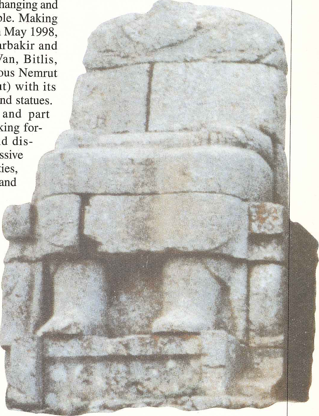
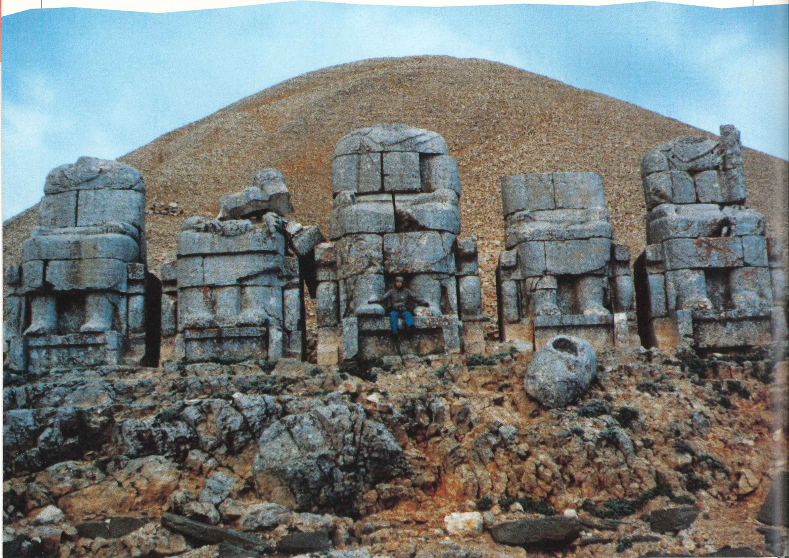
Nemrut Dağ (Mount Nemrut), part of the anti-Taurus range, rises to 2150 metres between Malatya and Kahta. Not unlike most of the other mountains in the area, it is famous for the remains of the massive statues and tumulus that rest on its summit. Nemrut’s peak was razed and rebuilt in self-praise by Antiochus (64-38 BC), King of Commagene, an independent Seleucid “empire” built on playing both sides of the Roman, Parthian fence. Antiochus saw himself on equal footing to the great king-gods of the Roman, Parthian and Persian empires and thus elevated himself to god status. Some believe that the crushed rock mound which now stands in place of the natural peak is actually the tomb of the self-labelled ruler.
Making your way up the 500 metre path from the car park to the peak at 05:00 on a May day, you freeze. The partially overcast sky was black with just a faint glow in the east. By the time we, and 50 or so others, ›p, the glow had spread across the horizon and gained a hint of yellow. The next forty-five minutes were an incredible show of colour and light. The feeling of being on top of world – an ancient world
— came to mind. The sun turned the decapitated statues and scattered heads a glowing yellow to dull orange with long, long shadows until finally the entire mountain was engulfed in light and the details of these 2000 year-old carvings came to life. Besides the impressive mountain range, Nemrut provides a spectacular view of the waters of the GAP, spreading like fingers into the valleys. As the cold sunk in and a drizzle began we had just enough time for a quick trip around the tumulus, three rolls of film and a çay with the mountain keeper.
On a short trip from Şanliurfa to Gaziantep we encountered the horrors of modern-day Turkey – driving. Very believable urban myths persist that it is the highest cause of death in the country. In the 150 km we witnessed no less than five, what seemed like major, accidents mostly involving large tanker trucks. This small stretch of Turkish highway is at times the busiest in the country. It showed and it was scary.
About 2 hours north of Diyarbakir is a small town called Lice. At one time Lice was a prosperous bustling town of Armenian and Kurdish tradesmen. In the late sixties, a devastating earthquake hit Lice killing a sizeable percentage of its population. Because of its strategic geographic location, Lice’s importance grew once again when the troubles began in 1984. In 1993 fighting was frequent and much of Lice’s population migrated westward.
In June 1997 I visited Lice. Its houses showed both the scares of the 14 year old struggle against the PKK and the earthquake. The villagers were curious of the little motorcade as we bounced through its small streets. After a quick run down main street we came to our destination: a school built by the Development Foundation of Turkey with assistance from CIDA in 1988. The school was designed for young women that normally would not have the opportunity for education. It also taught them home economics and skills development, mostly carpet weaving. In this little troubled corner of Turkey, a piece of Canada was having a positive impact on many young lives.
Unfortunately, in May 1998, I couldn’t visit Lice. Just before the trip to the region, a major operation against the PKK had begun that made Lice off-limits.
View the original scanned pages →
Originally published in bout de papier, Vol. 15, No. 4 (1998-1999) — Winter 1998/99 // Hiver 1998/99, pp. 28–31. Read the rest of this issue →