bout de papier, Vol. 10, No. 2 (1993) — Spring 1993 // Printemps 1993, p. 48
“Disaster, Ludwig, complete disaster!” wailed Miles Mercator, Deputy Cartographer-General to the Queen. “I foolishly sent the only draft of the new Karoobia map to my boss, Sir Sanford Sifton. He liked it, but he lost it!”
“Where?” asked ace logician LDC Liebnitz. “As far as we can tell, in his fifth Gin Fizz,” was the anguished reply.
Calming his friend, Liebnitz sought clarification. Apparently the Bureau of Charts and Graphs had been approached by the recently-formed Karoobian Konfederation to draw up and print its official new maps. The most difficult problem had, as always, been a seemingly small one – the demands of the ten states making up the new country concerning the colours they would be allocated.
Mercator went on: “We started out using this blank map here, with the provinces labelled A through J. Then each state delegate made his or her demands. I thought I’d go mad, but we actually found one (and only one) distribution that satisfied everyone.”
The demands were as follows:
1. The three states with Libertarian governments — the state marked E plus JIHAI and CALTRO — all wanted to be the same colour, unique to them.
2. The sole state with a Green Party government wanted to be green.
3. ERSATZ and BINGEN plus the state marked D all wanted to be blue.
4. FORMALDO, HITO and one of the two Constitution Party states wanted to be red.
5. The federal president insisted that his home state be yellow.
6. For some obscure religious reason, one of the colours most commonly requested could not be used for any corner state (A/B/G/J).
“That’s fine, as long as you know which states go in which spaces,” remarked Liebnitz. “That’s just the problem,” said his friend. “The whole political structure is new, they all took their own maps home with them, and the copy of the map and notes that Sir Sanford lost are the only ones we kept.” It did however turn out that Mercator had scribbled a few odd additional facts on a bologna sandwich wrapper.
A Aalto Puzzle Winner, Vol. 10, No. 1:
ALAN BONES, Economic
Relations with Developing
Countries Division, EAITC
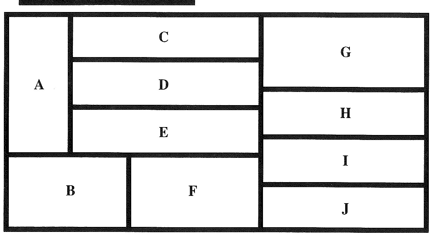
These were as follows:
7. No state name starts with the letter used to identify its space on the map.
8. GRENZ borders on three states ruled by the Renewal Party, one of them ARMORICA.
9. The capital of DONGEN is due north across the common border from the capital of INVICTUS.
10. No two adjacent states can the same colour, and the map uses the minimum number of colours. Based on this information, Liebnitz was able to assign a name, colour and governing party to each state marked on the map. Can you duplicate this feat? In addition (not necessary for answering the puzzle), can you deduce the anthem of the state marked A? Finally, don’t you think that Mercator should change his first name to Kilometres?
View the original scanned pages →
Originally published in bout de papier, Vol. 10, No. 2 (1993) — Spring 1993 // Printemps 1993, p. 48. Read the rest of this issue →